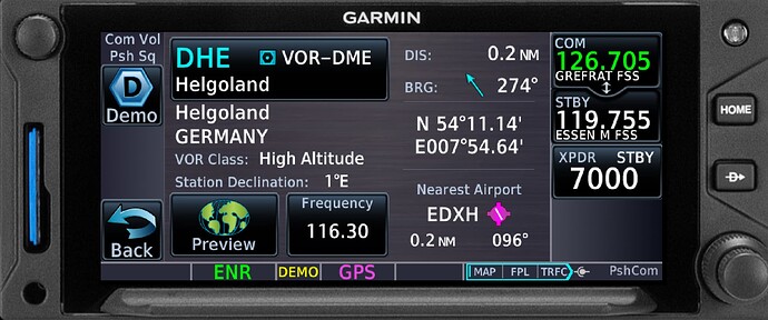
Hi! Since this VOR (DHE, 116.3) is back in service for more than 3 months now I was wondering why it still is missing in your database?
I flew there (EDXH) last friday IRL and was able to receive both VOR and DME components perfectly fine from 76 miles out at FL55.
Plz check the official German AIP here:
https://aip.dfs.de/BasicIFR/2025JUN12/pages/0AF1EA0908076675042E87F5350D29E8.html
(You need to press the “Print” symbol in order to see the high-resolution map, it´s located right in the middle of the German bay)
And here it is to be seen on the Visual Approach plate:
https://aip.dfs.de/BasicVFR/2025JUN17/pages/0974851DE13A5FE17E3C142EF1FD136A.html
Thx, Björn
Hi Björn,
Thank you very much for the report and the references. I can confirm that the DHE VHF navaid is missing; I can´t see any reason for that. Therefore, we will ask our data provider. I will keep this topic open, till we have received an answer.
Thank you,
Richard
Thank you, Richard ![]()
Hi all,
My interpretation is that the DHE VORDME is for VFR use only. It is not listed in the GEN 2.5 list of radio navigation of the AIP Germany. Furthermore, there’s no published coordinate data for it in the IFR AIP (even if they are available in the ENR 2.2 VFR AIP). There are similar observations in other countries of “missing” VFR navaids in the Jeppesen database (especially several NDBs in the US). That could be the reason
DHE was an enroute VOR and present on multiple airways (e.g. P729, P999) up until AIRAC 2502 inclusive.
As of AIRAC 2503, along with many other extensive changes to the Bremen FIR, it was removed from those airways and seemingly disappeared from Navigraph’s navaids list at the same time.
At that point, I seem to recall DHE was not even recognized by the CFMU route validator; this appears to have changed, and it is now recognized again, but nevertheless still isn’t an allowable FRA waypoint.
I’m guessing it was somehow “reclassified” in AIRAC 2503, possibly as VFR-only like Herve suggests.
Regards,
Tim
Hi Tim, all correct.
FYI, this is one of the very few CVOR‘s to remain in Germany, all the others I know of are DVOR‘s…
However, located right above, Germany‘s largest military training area for A2A missions is being used quite a lot these days and DHE is used as navigational source of course.
A „VFR only“ VOR does not exist in Europe, at least to my knowledge…
Best, Björn
You’re correct Björn. US has VFR NDBs as well as a few VHF navaids. At least they are classified as so. I didn’t check all European AIPs but I presume VFR “only” may be interpreted as navaids that are not included in IFR AIP navaid list, not used by any instrument approach and not part of any airway system but I agree that VFR “only” is inappropriate as far as they can be used by any aircraft under VFR, IFR or military flight rules.
Hervé
Thank you for clarifying, Hervé - totally agree ![]()
Top-level discussion with professionals here, I like that!!
Best, Björn
I don’t want to interrupt this really top discussion. Seldom to see such a high-level posting. Thanks, Herve, thanks, Björn and of course, Tim. Well done guys …
Anyway, we have asked Jeppesen ![]()
Cheers
Richard
![]()
![]() Na gut, und was haben sie gesagt? Wird´s im nächsten AIRAC dabei sein?? Die Spannung steigt
Na gut, und was haben sie gesagt? Wird´s im nächsten AIRAC dabei sein?? Die Spannung steigt
a tiny note, DHE is not used even for those that you mentioned. DHE was replaced by the collocated WELGO and further by ROCZO for all purposes of navigation (at least at the upper level)
and according to the AIP IFR Germany
AIP 4.1, it’s not an enroute NAVAID, even if it’s shown on Charts… a weird one from the germans I guess
Sooo, since 2507 is out - is it implemented now? Your charts still don´t show it..
Best, Björn
No Björn. It´s not included. I just checked the data. Also, we have not yet received an answer. Sorry.
Cheers,
Richard
PS: this VOR is also missing in the Lido data - so it must be any reason from the answers above, I guess
Thx for your answer, Richard.
Well, let´s think of it in this way: When I fly to EDXH in reality I use my G3X and 650xi to enter the route. Of course our real-world aviation database from Garmin has the VORDME, so the avionics can auto-tune it and on the way to the island this backup is always shown. That´s what you want when flying the high seas:
Now in FS24 you can fly “as real as it gets” - the airport is a bespoke one and I use GAIST to give me a little more of that atmosphere I know from reality. But the standard database has the VOR excluded - hey, no prob, since that´s the reason why I pay 100euros to have a more realistic representation of the navaids.
If someone believes there would be any reasons why the VOR shouldn´t be in - well, simply don´t use it.
But please, implement it - just to make me happy ![]()
Best, Björn
Will look what I can do for you Björn - we don´t like “unhappy” user ![]()
Keep you informed,
Richard
Björn, you can expect the DHE (HELGOLAND) navaid starting with AIRAC 2508. I have manually added it as a tailored record in our systems.
Hope you are happy next month ![]()
Servus aus Wien
Richard
Thank you so much, Richard!!
All the best!
u. LG aus dem Westmünsterland ![]()
Björn
Published coordinates (Germany VFR AIP) are a bit inaccurate. Real data are N54 11 08.5 - E007 54 38.4 - Altitude 26 ft - Documented operational coverage is 60 NM - Station declination is 3E
Regards
Hervé
Thank you, Hervé! Best, Björn
