As above, the ILS on KDEN rw35L bought me over the threshold at around 200ft.
Will try some more runways in due course to check!
Hi,
I guess this is more a scenery issue, because I have flown this with the stock scenery and here all looks correct so far - possible that the thresholds are not 100% correct in the FlightBeam scenery, I don´t know. Remove the scenery and try the approach again, you will see it´s absolutely correct so far.
Here my approach:

I´m nearly perfect. the altitude shows approx. 5490ft above the threshold. When you look on the charts you see that the threshold touchdown zone is 5434ft and the threshold-crossing-height 57ft = 5491ft

So, all looks good with out the 3rd party scenery - means at the least the data are correct located and also the elevations.
Cheers,
Richard
Okay, I raised it with Flightbeam and they insist with stock navdata that the airport works perfectly, so of course navigraph is to blame… and you guys say they’re to blame… So its a little bit of an impasse in terms of finding a solution that works… 
So that mean, you also can confirm that the approach is correct, when you use only the stock data with the Flightbeam KDEN scenery? Please can you try to make a screenshot, equal to mine over the treshold 35L - KDEN scenery installed but only with the stock data that we can see if there is any difference on the elevation or the altitude?
Thank you,
Richard
Sure I’ll give that a go now.
On another note, I guess you include data for Kai Tak? The IGS has quite a short range, not sure if thats you guys or the Ali05 scenery
1 Like


Threshold crossing at 5455 not 5490. So someone’s elevation is off by 40ft. Looking at Charts, that would be Flightbeam.
Ok, I have installed the Flightbeam KDEN scenery and have tried the 35L approach, but I get exactly! the same result as without it. The altitude over the threshold is exactly 5490 ft (touchdown zone 5434 ft + threshold crossing height 57 ft = 5491 ft) - so really, really perfect.


So, far away from too high and more far away from 200 ft … the scenery works perfectly with our data. It looks you have any other glitch in your system, or at least with KDEN … have you de-installed the default KDEN, as Flightbeam recommend?
Cheers,
Richard
Hiya,
yeah using the navigraph data I got 5490 as well. But the elevation of the runway is then 5380 or so. So it seems at least for me, the runway is lower… I have uninstalled KDEN from asobo…

Ok, and what is wrong now with this?
The runway elevation for 35R is 5367 feet, so it´s identical to your screenshot.
Here my tests with runway 35R - runway elevation should be 5367 feet:

Flightbeam KDEN installed, AIRAC 2112r2 installed shows 5362 feet … so perfect:

Flightbeam KDEN installed, AIRAC removed using only stock AIRAC shows 5363 feet … also perfect:

So, there is no different - if you have installed the our files or not - the runway elevation is in both cases identically.
Cheers,
Richard
Yeah, I think the issue is mainly with 35L. 35R has the correct TDZE and then the glidepaths all match up, but I think the TDZE for 35L is about 50ft too low at 5380 (actually almost the same as 35R) which is then making the correct ILS, which comes in to aim for 5430, appear too high.
Runway 35L - runway elevation should be 5431 feet:

Flightbeam KDEN + AIRAC 2112 rev. 2 installed shows 5364 feet - approx. 65 feet too low:

Flightbeam KDEN without our data using only stock data shows 5364 feet - exactly the same value:

Default KDEN + AIRAC 2112 rev. 2 installed shows 5444 feet - approx. 13 feet too high, but I would say ok:
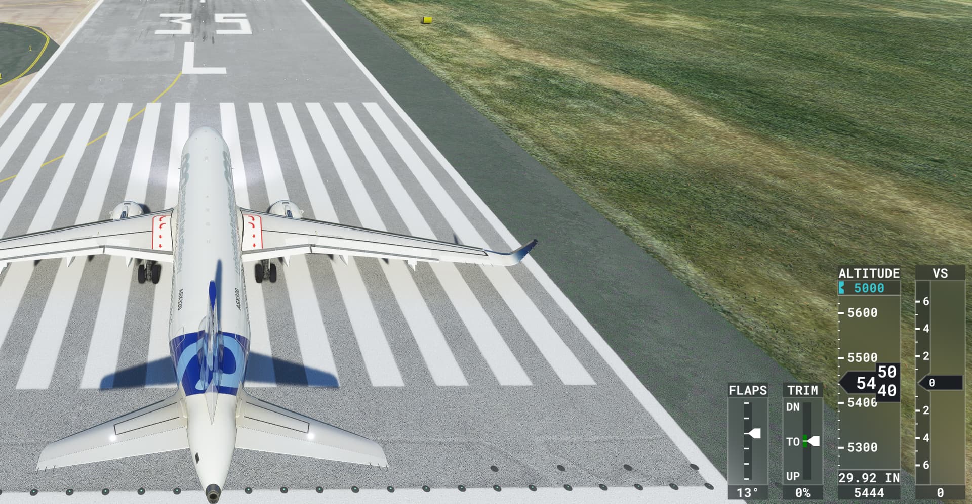
Default KDEN without our data using only stock data shows 5444 feet - exactly the same value:

What I want to demonstrate here is only, that this has nothing todo if you have navdata installed or not and the reason is, because we don´t provide any runway and/or runway-deformation information in our files, so we have no real influence about this value.
I have also looked into the Flightbeam KDEN file and here the elevation for 17R is 5354 feet and for 35L 5355 feet. So nearly 80 feets to low as in the real-world.
Here a part of the de-compiled file from the Flightbeam KDEN scenery:

The first entry of the RunwayDeformation Element is for 17R and the second one for 35L - both in meters.
As conclusion, I´m pretty sure now, that the runway is simple defined to low and therefore you get the large “vertical offset” during the approach. More on analyzes are not possible sorry … but I hope you see now, that this has nothing todo, if you have installed the navdata or not …
Cheers,
Richard
Yes I can see that its the flightbeam problem. I have had a response from them saying they can’t get everything accurate as the airport fluctuates a bit but that caused a lot of other issues with the scenery so they had to basically set it relatively flat…
Would it be possible to include a navdata file that accounts for that or is that too tricky to implement?
Theyre waiting on the SDK to improve terrain maps before putting it all right. I remember the original KDEN had some crazy bumps and so on due to this terrain.
No, we can’t do anything as a workaround sorry. To overlay some other data will “destroy” a lot in the scenery and when Flightbeam write that there are special reason for this more or less flat runway, than they had a reason for that.
They have surely much, much more knowledge in building sceneries than I (we) have. So, I would trust Flightbeam. Sorry but thanks for the feedback.
Cheers
Richard
This topic was automatically closed 2 days after the last reply. New replies are no longer allowed.